The rusty hand painted sign at the turning was intriguing - “Sindh Culture and Tourism Department. WORLD’S BIGEST FORT RANI KOT. 2500 Labours had prepared FORT RANI KOT 22 miles during 3-4 years about (before) 325 BC. NOT ACCURATE” (sic).
We were travelling north from Hyderabad on the West bank of the Indus towards Moenjodaro – the T List site of Rani Kot fort lies around 30kms west from the main highway into the mountains of the Khirthar National Park. The Indus valley is flat and largely well irrigated (with the help of one of the World’s largest irrigation systems) all the way up the length of Pakistan but, a bit like the Nile, in Sindh at least it doesn’t take that long if one sets off at 90 degrees to reach mountain and desert. The road is surfaced to the fort now – various sources still say that a 4x4 is needed. We saw no other traffic along the way apart from a few tribes people walking with their goats and a couple of camel riders. Our guide remembered a few years earlier getting his vehicle stuck in the sand in the summer heat and having some considerable difficulty in summoning assistance – this is quite wild country
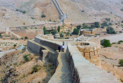
Then, what is called “The Great Wall of Sindh”, comes into view snaking its way across the hills in a way certainly very reminiscent of the classic photos of the Great Wall of China. The road continues through a gap in the wall where a river bed passes – this is the Sann Gate, one of 3 through the wall situated at the W/S and E cardinal points. Rani Kot’s claim to be the world’s “biggest fort” relates to this wall which extends to some 30kms in an approximate rectangular shape, the northern side of which is a steep cliff which doesn’t actually need a “wall”. But why? There is no evidence of there having been anything much within the walls which required a fortification of this size. Which takes us back to that sign at the main road and its “(before) 325BC”. In fact the earliest record of the walls dates back only to 1812. In some form the wall certainly predates this, but, by how much is a mystery. As stated on the sign 325BC does however seem to be excessively early and not likely to be accurate!
But we had reached as far as we could go. The metalled road continued for another kilometre inside the walls and then reached a part-completed concrete bridge. There was no alternative for our saloon car – a 4x4 could probably have progressed by following the river rather than the road but we had to make do with the walls at the main entrance. A few kms further in there is apparently a small ruined fort, or at least a residence for the Mirs who ruled the area from the mid 18th Century.
In true “Great Wall” style we climbed the walls on both sides of the entrance and took in the views. Examination of the walls close up confirmed the impression from a distance – this part of the wall had undergone considerable recent reconstruction as shown by the new cement and a number of features such as archways in locations and to designs which didn’t really seem authentic. I have since discovered that the renovation work was stopped and that an investigation is underway as to how such poor renovation work could have been allowed
So what of Rani Kot’s chances? It has in fact been rejected once already – back in 1984 under the title of “Rani Kot Fort (Kirthar NP)” with the statement that “The Bureau, while taking account of the great importance of this site for the Pakistani national heritage, felt that it did not meet the criteria of OUV as understood by the Committee”. For some reason Pakistan reintroduced the site in its 1993 T List and, as per the report in Dawn above, obviously still harbours ambitions for it. We enjoyed our visit and the view of the walls is quite impressive but I can’t see a WHC reaching a different conclusion in future.
More on
Comments
No comments yet.
