With the Struve Arc being “in the news” on this site because of the 2016 “WHS Travellers Meeting” visit there, it seems a good time to add a review of another location which, as far as I can see, hasn’t previously been reviewed here - UNESCO Ref 1187-013 Porlom II in Finland which was visited by us in Aug 2016.
The site is very conveniently situated about half way between Helsinki and the WHS of Verla Board Mill - a visit to it by car from Helsinki will still get you to Verla in time for lunch. At around 115kms out of Helsinki, turn north off route 6 along 1771 (The WHS is not signed at this turn off). After 10kms you will reach the village of Porlammi. There, take 1751 north for a few kms and you will see a sign to the WHS pointing right (north) along a dirt road which leads to a beach (In Finnish = “Uimaranta”) on the nearby Lake Pyhäjärvi (apparently, there are 39 lakes in Finland named “Pyhäjärvi” which means “Holy Lake” so, if you are using map software, be sure you get the right one!). There are no more signs along a road which has a fair number of junctions - you just have to navigate on dead reckoning north towards the lake following the most “used” tracks!
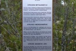
If you reach the shore you have gone about 300 metres too far. Set back from the road in light undergrowth to the left as you come from Porlammi there is a sign with a full description of the Arc with maps etc and an indication that the “holy grail” is a, pleasingly exact, 420m away! From there a footpath climbs slightly through the forest, carpeted with reindeer moss and plants heavy with berries. You will arrive at a bald rock overlooking the lake and, behind you, will be the object of your journey - the actual marker which is set on a wooden post with a possibly significant “line” cut vertically into it implying that it has been located to the accuracy of a centimetre!! The first notice board states that “it was measured in 1833 by marking the point in the rock with a drill” but I could see no drill hole and the marker wobbled disconcertingly in its setting when pushed – so, how accurately the marker has really been placed is anyone’s guess.
An interesting fact on the first notice board is that, at the time of Struve, this area was free of trees – this was important of course to provide 360 degree sight lines for the triangulation measurements. Today you can only look north across the lake. Another fact mentioned on the notice board is that, in 1922, a re-measure took place and the Finnish Geodetic Institute placed its triangulation point 64.6m away. This was in use until the 1980s when satellite based measurements started. But we could see no signs directing us towards this second point. We were, by the way, the only visitors on this August Wednesday morning.
Which brings us to the “photo of record” for the site! I thought of using one of me looking “triumphant” whilst clutching the marker post (or one of Mrs Solivagent looking distinctly unimpressed) but that would break my "rule" of not using personal “snaps” so it has to be just the marker and a few moss covered bushes!
4 days later on our trip around Finland we were driving round the Gulf of Bothnia from Lulea/Gammelstad (Yes, I know they are in Sweden but Gammelstad was only around 800kms return additional to our Finnish route so we could hardly miss it!) with the aim of getting within 200kms of Rauma that evening - a journey of c650kms. At Tornio, on the Finnish/Swedish border we passed the sign showing that we were within 3 kms of the church which is the location for Struve Arc Ref 1187-11 and I had to ask myself whether I was a prisoner of an obsession or a man of free will!! Where would the “value add” have been? It wasn’t even as if the site hadn’t been reviewed here? I resolved my dilemma by convincing myself to “trade” a visit to another Struve location for a visit to the Finnish T List site of “The large Stone age ruin of Giants Castle at Pattijoki” – near Raahe and still 200kms south. Was I wrong?
Joking apart, I suppose anyone interested in WHS has to visit at least one of the Struve locations but they do seem to represent the “reductio ad absurdum” of the scheme whereby most of the locations have nothing present which needs “preserving” and those that do (like Tornio Church) are only of importance for purely associative reasons.
More on
Comments
No comments yet.
