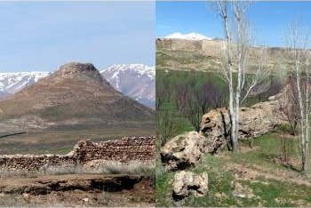
Wiki describes Takht-e Soleyman as being “located on a volcano crater rim” whilst the UNESCO Web site states “About 3 kms west is an ancient volcano, Zendan-e Soleyman which rises about 100m above its surroundings”. In fact the former is not on a “volcano crater rim” and the latter is not a 100m high “ancient volcano”!
Both sites have been formed by the same, rather different, geological process. Britannica says (correctly) of the main site “The base of the temple complex sits on an oval mound roughly 1,150 by 1,800 feet (350 by 550 meters) that was formed by the outflow of a deep artesian spring, the waters of which collect in a large lake at the southern half of the hill and have heavy concentrations of dissolved calcium. The resultant limestone formation, created by the residue of the periodic inundation of the spring, rises to about 200 feet (60 meters) above the surrounding countryside”
But Britannica isn’t so accurate with Zendan-e Soleyman which it describes as “a modest-sized extinct volcano”! Why it couldn’t have carried forward the same geological process it has correctly identified as having created Tahkt-e Soleyman isn’t clear. It isn’t alone however! The AB evaluation describes it as “This hollow, conical mountain, an ancient volcano”. On the other hand the Nomination file is very careful to describe the Zendan as simply being “volcano-shaped”. Whilst the notice board at the foot of the hill provides a correct and succinct explanation - “This mountain has been created by calcic sediments of an artesian spring”.
So, both hills have been created by a process of deposition from warm saturated water which has, over many thousands of years, created limestone “Tufa” (not to be confused with “Tuff” which is a porous volcanic rock) or “Travertine”, which has gradually been raised above the previous ground level in the form of an approximately circular hill – "high" in the case of the Zendan and still relatively “low” in the case of the Takht. The only “Volcanism” involved is that which is deep underground in the Zagros Fold which has heated the underground waters - but that geological process doesn’t make, for instance, the Roman springs of Bath a “volcano”!
But you can see how this misunderstanding has occurred. Zendan-e Soleyman is remarkably “Volcanic” in shape (Photo). It is only when one climbs it (Not to be missed, both for the hill itself and the views all around. As per normal Iranian practice, there is an “additional” 80k IR “entry” fee collected by a guardian who suddenly appears from nowhere!) and sees the geology of the rock, that one can appreciate the true mechanism which created it. It helps to have seen Takht-e Soleyman first, since its geology is somewhat easier to understand - the water is still present and the rising stone “lip” around the lake created by the deposition from overflows is clear. Given long enough, and without the human intervention which has diverted the overflowing waters via cuts made in the lip, it too might one day have become as equally “Volcanic” in shape and height as its neighbouring hill! Apparently Zendan-e Soleyman still had waters in its hollow centre in the time of its initial use as a shrine (remains of the original buildings are still visible as one climbs the hill) - one can imagine a certain consternation about what the “Gods” might have been "telling" the believers when it dried up around 700-500BC – at least they had the other spring to use!!
The AB is also incorrect in implying that the entire site was chosen as a religious centre because it provided, in “natural” form, the 2 main Zoroastrian “elements” - fire and water (“The State Party presents Takht-e Suleiman as one of the most important ancient sanctuary sites in the country, characterised by the presence of fire and water (volcano and artesian wells).”). I have read and re-read the Nomination file and I can’t find any reference to any claim by Iran for any “Volcano” having provided any connection to Zoroastrian “fire”. It would have been difficult for it to have done so of course, since there never was any “volcanic fire”!! It is quite clear that the location’s prime importance to Zoroastrianism was the presence of unlimited water from the Earth (hardly surprising in a land as generally short of water as most of the Iranian plateau). Zoroastrianism grew out of earlier beliefs which gave primacy to Water and it is thought that Fire only became important later - and its “sourcing” at temples did not require a “volcano” (let alone an “on tap" supply from local gas as per the one in Baku today)!! See this Wiki article on the introduction of “fire” to the religion and the rituals regarding its sourcing - https://en.wikipedia.org/wiki/Fire_temple
.
Another interesting geological formation within the site boundaries which shows the extent to which the waters of the area can “lay down” limestone is the so called “Dragon Wall”. This snakes its way across the fields below Takht-e Soleyman. The streams flowing off the hill created a “wall” around 2 metres high with a channel at the top - this being raised ever “higher” by further deposition - until the waters were diverted by man! So, the channel is dry now and the “wall” is broken (Photo). The easiest place to see it is to go down hill from the main entrance and stop after the T Junction on the right. Climb the low mound - the Wall passes through the orchard in front of you. (It is easily visible on Google satellite view at 36.600645 47.231964).
More on
Comments
No comments yet.
