Senegal
Bassari Country
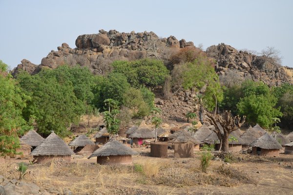
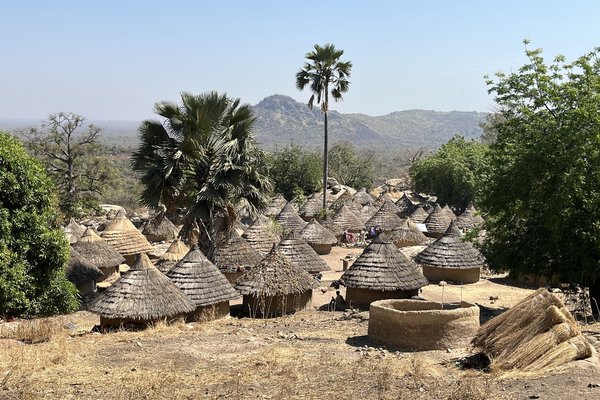
Bassari Country: Bassari, Fula and Bedik Cultural Landscapes represent an isolated, multicultural society of communities who practice traditional agriculture.
A mix of Bassari, Fula and Bedik peoples live in agricultural villages that were settled by several waves of migrations from the 11th-13th century on. The villages are located in a hilly, difficult-to-access landscape.
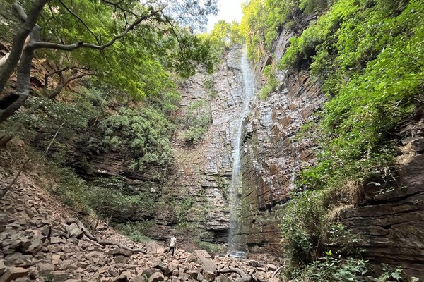
Community Perspective: the villages are hard to reach, but Stanislaw visited three of them in Bedik Bandafassi. Els went to Andiél in the same area and checked out the Dindefello waterfall.
Site Info
Official Information
- Full Name
- Bassari Country: Bassari, Fula and Bedik Cultural Landscapes (ID: 1407)
- Country
- Senegal
- Status
-
Inscribed 2012
Site history
History of Bassari Country
- 2012: Advisory Body overruled
- Referral was suggested by ICOMOS
- 2012: Inscribed
- Inscribed
- Type
- Cultural
- Criteria
- iii
- v
- vi
Links
- UNESCO
- whc.unesco.org
All Links
UNESCO.org
- whc.unesco.org — whc.unesco.org/
Community Information
- Community Category
- Cultural Landscape: Associative
Travel Information
One thousand visitors or fewer
Recent Connections
-
Extensions on Tentative List
Paysage culturel Bassari (Guinea) is ad… -
Gambia River Basin
It is thought that Dindefelo Falls flow… -
Living indigenous religions
"the intertwined complex of practices, …
Connections of Bassari Country
- Geography
-
-
On National Border
Location 001 - Bassari Salémata borders Guinea to the South. -
Contiguous National Sites
Bassari Country (Bassari Salémata), via the buffer area, with Niokolo-Koba National Park -
Gambia River Basin
It is thought that Dindefelo Falls flows into the larger river systems within the Niokolo-Koba National Park, which ultimately drain into the Gambia River.
-
- Trivia
-
-
Minority communities
"The Bassari are an ethnic group who live primarily in Senegal, with some diaspora into Gambia, Guinea and Guinea-Bissau. They are a matrilineal society stratified into different co ed social groups by age.[1]: 46 The Bassari speak a Tenda language called o-niyan...... The total population is estimated to be 15,000" (Wiki)See en.wikipedia.org
-
- History
-
-
Neolithic age
Archaeological research has yielded some evidence of the human occupation of the region since the Neolithic age, in the forms of worked stones, pebble-tools, etc (AB ev)
-
- Architecture
-
-
Vernacular architecture
traditional architecture (AB ev) -
Earth Architecture
"huts built in the ritual villages have earthen walls; in contrast, huts outside of the villages are made out of bamboo" (AB ev)
-
- World Heritage Process
-
-
Extensions on Tentative List
Paysage culturel Bassari (Guinea) is adjacent and has the same values, although it is not explicitly described as an extension.
-
- Religion and Belief
-
-
Sacred Forests or Groves
"ICOMOS observes that the preservation of the landscapes and their settlement pattern, along with the traditional architecture, the sacred forests, the sanctuaries etc bear credible witness to .." (AB ev) -
Taboo
"the age classes, the sacred prohibitions concerning the consumption of certain products" (AB ev), "Même si les autres sites sont comparables en terme de respect de la sacralité et de tabous" (nom file) -
Living indigenous religions
"the intertwined complex of practices, social rules, rites and beliefs that have helped the Bassari regulate the interaction between men and their living environment and have produced a cultural landscape shaped by and imbued with cultural traditions and spiritual meanings that persist in a lively dynamic of transmission" (OUV)
-
- Human Activity
-
-
Masks
especially within the age-passage rites that dances and masks play an important role (AB ev) -
Man-made Terraces
Fields are organised in terraces (AB ev) -
Pastoralism
"bear outstanding witness to the cultural specificity and interaction between the Bassari/Beliyan, Bedik, and Fula people in agro-pastoral, social, ritual and spiritual practices" (OUV statement), "The Fula people are distinguished from the other two groups both for their economic base – they were mainly farmers and sheep farmers ...The Fula villages are dispersed in all the Bassari and Bedik territory, mainly in the plains where space for pasture is available." (AB ev) -
Rice cultivation
The Bassari landscape is marked by terraces and rice paddies (AB ev)
-
- Timeline
-
-
Built in the 11th century
first documented population movement phenomenon dates back to the 11th - 13th centuries (AB ev)
-
- Visiting conditions
-
-
One thousand visitors or fewer
"There are no reliable visitor statistics for the region..... Very touristy places like the village of Dindéfello attract only a few visitors per week. The village of Ethiolo in Bassari Country can see a month go by without receiving visitors."(nom file, translated from French)
-
News
No news.
Recent Visitors
- Philipp Leu
- Luis Filipe Gaspar
- Roman Bruehwiler
- Ask Gudmundsen
- Olli-Pekka Turunen
- Malgorzata Kopczynska
- Roger Ourset
Community Reviews
Show full reviews
Bassari Country is almost contiguous with that other East Senegal WHS, Niokolo Koba National Park. However, you must drive around the park (2.5-3 hours) to get to where the Bassari live. Along the way, you will already see plenty of traditional houses in mixed villages by the roadside.
We started our visit at location #3, Dindefello. This is a typical mixed village on lower ground, inhabited mostly by Fula and with ‘modern’ houses as well. It has a fine setting with the massive wall of the Fouta Djalon Massif rising behind it. On its main street, there’s a Visitor’s Center where you have to pick up a local guide and pay for access to the waterfall.
Dindefello Falls are the region’s pride but it is hard to imagine a sizeable waterfall in this dry landscape. We had to walk for half an hour through the forest to get there. The path is adjacent to a river, where women cleaned their laundry by ‘beating’ it on stones. The noise sounds like gunshots. The waterfall was no disappointment: a long, sheer drop coming from the rocks. A pool had formed below it; my guide and driver tried it, but the water was too cold in the early morning for a swim.
The guide had promised me a visit to a ‘real real’ village as well. After some deliberations with the guys at Dindefello reception, we were given a contact number for a local guide who could give us access to Andiél. This …
Keep reading 0 comments
Visited February 2017.
It is not easy to get there – west of Kedougou there are no roads and I can hardly imagine how they travel in the rainy season…
This inscription contains three parts: Bassari (Salemata village as a starting point), Bedik (Bandafassi) and Fula (Dindefelo). The closest to the city of Kedougou is Bedik Bandafassi which in my opinion is the most interesting – some small villages on the top of the mountains, with only 3000 people living there. It’s good to visit at least three, four of them but you need one day of very intensive walking and a guide because they are not easy to find. It is not a tourist trap and the Bedik people are very friendly. Just give some money to the chief of the village and walk freely, take as much pictures as you want. Bedik speak their own language, belonging to Niger-Congo family and has some similarities with some Tenda group languages. Their religion is a blend of animist and Christianity, and their most important village – Iwol. The Bedik came here possibly in the 18th / 19th centuries from Mali, and most of them bear Keita as their family name. Most of their original villages are deserted now because of the lack of water.
Dindefelo is less interesting and I think half day moto trip from Bandafassi is enough to see the most representative villages and the waterfall, the biggest one in this part of Africa – but it is …
Keep reading 0 comments


