
I went on an organized day tour from Beirut to Baalbek - one that efficiently also encompasses the WHS of Anjar (and some wine tasting at Ksara, but I am not fond of that). We were a group of six, of which I was the only one having come to Lebanon as a tourist. The others were here for work or study.
Baalbek lies quite deep into the Bekaa Valley, which means that we first had to cross Mount Lebanon. It had been snowing until last week, and snow was still visible beside the road at the mountain pass. The road is not in great shape and is as busy with traffic as everywhere I have seen so far in Lebanon. The Bekaa is a fertile valley and the main agricultural zone of Lebanon. There were lots of fruit and vegetable stalls next to the road, as well as hanging slaughtered animals. Remarkable I also found the numerous tents of Syrian Bedouins, who apparently come here to work as agricultural labourers. The current city of Baalbek mostly has a Shi'ite population, and they quite recently built a glittering new mosque not far from the archeological site. In town, there also is a large Palestinian refugee camp.
We started the tour with a quick visit to a quarry for the Baalbek site, at which it becomes clear how big the monoliths were that were used for construction. The Baalbek complex begins with the Temple of Venus, just outside the …
Keep reading 0 comments
At turbulent times in recent Lebanese history, Anjar was a difficult site to visit. Even now, in the calm 2010s, the Dutch Ministry of External Affairs warns against going there. The site is located only a few kilometers from the Syrian border. It was used as a Syrian military base during its long involvement with the politics of neigbouring Lebanon. Everything was very quiet though when I visited in early April 2012. I guess the Syrians are too busy with themselves at the moment.
Having just visited Baalbek, Anjar comes across as a lesser example of Imperial Roman architecture. In fact, it is from a much later date, the 8th century: the engineers just used a lot of Roman and Byzantine examples. The most impressive is the strict layout of the city, with a north-south and an east-west axis. At the crossroads, there is a perfect example of a Tetrapylon.
The story here is that all small compartments along the axes were used as shops, hundreds of them. That would have made the city one huge shopping mall. I wonder where all the people came from who bought stuff here.
We spent about 45 minutes at Anjar archeological site (I was on a tour from Beirut). That was sufficient for me, it is mostly ruins that you can see. Besides our group of 6, a few other foreign individuals were visiting at the same time. The site is very low-key: it lies on the edges of the …
Keep reading 0 comments
Although Byblos (nowadays known as ‘Jbeil’) lies only 35 km north of Beirut, it took the rickety local bus number 6 more than 1.5 hours to get me there. As always in Beirut we got stuck in traffic, and then slowly proceeded through casino-town Jounieh until we reached the Mediterranean. Finally, we were leaving the highrise buildings and American fast food restaurants behind. The drive northwards along the coast is quite pleasant, though many good spots have been taken over by large beach hotels and exclusive fish restaurants. The bus driver dumped me at an overpass, from where I walked down into the city center of Byblos.
It is not difficult to find your way to the archeological site: just walk to the Crusader Castle, which is the highest building in the area. After paying the ´foreigners´ entrance fee of 8000 LBP (4 EUR), I started the long circuit of the complex. Paths lead to all corners of the site, with information boards in English, French, and Arabic to explain what once was here. The origins of Byblos lie in the neolithic and chalcolithic, so remains of this period are limited. Better preserved is the Roman heritage: a small theatre at a splendid location overlooking the sea, and a row of columns along a former Roman road. At the far end of the complex lies the Temple of the Obelisks, an Egyptian/Phoenician construction. A group of obelisks still is standing upright, which makes it look like a cemetery.
…
Keep reading 0 comments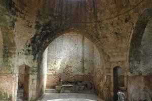
Tripoli is a much different city from the rest of coastal Lebanon. It has a large majority of Sunni moslim inhabitants, and its monuments date back mostly to the Mamluk and Ottoman periods.
The city is easy to reach by express bus from Beirut - it takes just over an hour. The Crusaders left a castle here too, a huge citadel that overlooks the crowded city centre. It's a good place to start any visit to Tripoli. In fact for me this was the only place that the city's many mosques became visible to me. Walking on the ground, in the crowded souks, the monuments are difficult to recognize. The citadel is used by the Lebanese army nowadays, possibly keeping an eye on the road to Homs!
Tourists are still welcome to enter though. Noteworthy (besides the views) is a Roman tomb or sarcophagus near the entrance, with decorations of funny faces on it. I have not been able to find any description of it on the internet, and I only think it is Roman because I overheard an Italian guide speaking about it to her small tour group. Yes, a handful of other western tourists showed up.
After the citadel I tried to find some of the Mamluk/Ottoman mosques, medressahs and hammams. My copied map from the Bradt Guide to Lebanon proved no help. I just wandered around for awhile in the souks, looking for the Soap Souk and the Grand Mosque in particular. I only managed to find …
Keep reading 0 comments
This is a whole different side of Lebanon, and worth the trek out to the north of Mount Lebanon. I went there on a day tour with Nakhal Tours, a popular and well-organized tour company from Beirut which I had also used for Baalbek/Anjar. There are public buses too, to the town of Bcharré for example, but it would be too much to visit the monasteries and the cedars in one day that way.
We first drove up in the mountains, already enjoying fine vistas over the Qadisha Valley and the villages around it with their large churches and red-roofed houses. I had seen snow on the mountain tops on my way to the Bekaa Valley too, but here you're much higher (about 2,000 m above sea level). There are ski resorts also. No wonder the 'Forest of the Cedars' was covered in snow about 1 - 1,5 meters high. The 'Forest' is a pitiful patch of a few hundred trees, leaving some of my fellow tourmates wondering why we had travelled for hours to just see that. It is quite a touristy spot however, the road along the forest is packed with souvenir stalls. There were other tour buses full of Lebanese daytrippers also.
After half an hour or so, having photographed every single remaining cedar, we went back into the bus to descend into the valley. This is an exciting ride, as we had a big touring car bus and the road is very narrow and …
Keep reading 0 comments
This is the third Lebanese WHS displaying mainly Roman remains. And there is another one (Anjar) heavily influenced by Roman architecture. It does not make me feel very happy that I still 'have to' check out dozens more of them around the Mediterranean - in Algeria, Tunisia, Libya for example. Roman remains have withstood the test of times so much better than that of other civilizations, so it seems.
I visited Tyre on a day trip by public transport from Beirut. Although it is only 80km away, the bus took about 2 hours (including a change at Sidon). Tyre lies south of the Litani river, which means that is in the former danger zone between Lebanon and Israel. UNIFIL troops in their white tanks still patrol the streets. There is some ostentatious flag-waving and billboards with political/religious leaders going on, but nothing too aggressive. I only saw my first billboard featuring the head of Ayatollah Khomeini, and a medical clinic named after him.
Daily life in the streets of Tyre is as laid back as anywhere in Lebanon. I started my sightseeing at the Al-Mina ruins in the center of town. I was the only visitor. The site consists primarily of rows and more rows of columns. After about 15 minutes you have seen it all.
Then it's a further walk of about 20 minutes to get to the other archeological site, Al-Bass, at the edge of town. You can see the hippodrome from afar, but unfortunately, …
Keep reading 0 commentsEls Slots
Ensemble du site naturel de la region du Chouf
Ensemble du site naturel de la region du Chouf (Removed from tentative list)

Although this sounds like a natural WHS, the proposed area also includes the monuments and archeological sites in the region. Among these are Beiteddine Palace and Deir al-Qamar, two sites that have been on the T-List before on their own merits.
I went to both places on a half-day trip from Beirut. It is only a short drive from the Lebanese capital, and surely in the weekends it is a popular outing among locals. After having seen much of Lebanon already during the past week, I was still surprised by the originality of this region. Many Druze live here too, the most religious of them still wearing their traditional black and white costume.
Deir el-Qamar has a well-preserved town center, with a pretty little mosque dating from 1493. We visited the local wax museum in an old palace. Here all the great leaders of Lebanon and the World have been put together. Mubarak is still going strong here, and the older Bush stands brotherly beside Hezbollah-leader Nasrallah.
The highlight of this mountainous region I found the Beiteddine Palace. Room after room is decorated in an exuberant Arab-Italian style. It has a wonderful luxurious hammam. And the former horse stables are now used for the safekeeping of dozens excellent Byzantine mosaics (originally from the southern coast). A site not to be left out of any Lebanon itinerary, and it would make a nice new WHS because it focuses on a different period in Lebanese history.
Keep reading 0 comments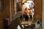
Saida or Sidon is an easy city to visit from Beirut. It is one of the many coastal cities in a row, sharing the rich history from Phoenician to Romans to Crusaders to Mamluks and all in between. After Byblos and Tyre, similar sites, chances of Saida getting WH status too are very slim in my opinion.
I stopped in Saida on my way back from Tyre to Beirut. It's about an hour each way by public bus. Saida has a prominent Crusader Sea Castle on a small island off the harbour. The distinguishing part of town though are its islamic remains, notably the still-functioning souks and the caravanserai Khan el Franj. It's a pleasant city to wander around for an hour or so and enjoy a good lunch.
Keep reading 0 comments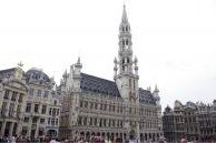
The Grand Place of Brussels is an astonishing artwork. Considered by many, whose myself, as one of the most beautiful squares of the world, it is composed by many guild's and merchant's houses, the city hall and the King's house. The city hall was build during the first half of the 15th century. This site testifies of the wealth of the merchants and of the guilds in Northern Europe during centuries. I visited this site in June 2011 and found the place magnificent.
Keep reading 0 comments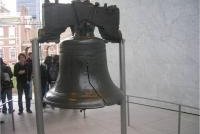
Independence Hall in Philadelphia is the place where the Declaration of Independence was signed the 4th of July 1776 by 56 men representing the 13 colonies. The building, built in 1732, worth a lot by the events it testifies of. Through it, we can think about events as the first independence of a european colony, the independence war following it and the establishment of the United States constitution.
Keep reading 0 comments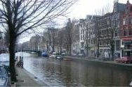
The canal ring area of Amsterdam lays on more than 100 kilometers. With 1500 bridges linking 90 islands, the canal area is made of 5 ring canals, built at the beginning of the 17th century, and the historic centre (Centrum) of Amsterdam.
The area is really beautiful and full of historical treasure dating from the period where Netherlands and its maijor cities were a huge economic force. For the testimony it carries on and its beauty, the place really worths its WHS ranking.
Keep reading 0 comments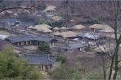
Yangdong and Hahoe Folk Villages are traditional and historic Korean villages mostly occupied since the Joseon Dynasty. For now, I have only visited the Yangdong village, located 16 kilometers of the historic city of Gyeongju. Korean aristocracy was living here under the Joseon Dynasty. The village comprises several Korean National Treasures.
Although some part of the village are unoccupied nowadays most of the folk homes are still used. Fifty-four historic homes are more than 200 years old. Mostly located on the side of a hill and on the bottom, this village is a fine example of Joseon Dynasty architecture and traditions.
To get to this village, take one of the several different buses going from Gyeongju bus terminal to Yangdong village in almost one hour.
Keep reading 0 comments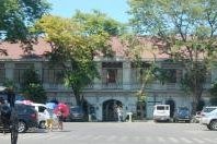
The reason why many people can't seem to appreciate Vigan is because they just zoom in to Calle Crisologo - forgetting that the the whole town is inscribed as WHS. I can't blame them though as even the local promotion of Vigan as a heritage site is only focused on that narrow street. In fact, it is one of the few towns where in the whole area is under the WHS inscription (others have specific areas - usually their old districts, some only have designated monuments such as churches and select old buidlings). So, how should Vigan be appreciated? The beauty of the trading town of Vigan is in the urban planning utilized in designing the place. It happens to be the best Spanish colonial planned town in Asia. Sadly, other parts of Vigan are neglected already and are not highlighted for their cultural heritage, and importance. Recently, there was the introduction of the Vigan River Cruise - though i have not yet personally tried this - that goes through the history of the town with presentations, cultural shows, and lectures. It is interesting to note that the cobblestone street of Calle Crisologo is already a reconstruction - the stones were dug under 3 layers of modern concrete streets and later on put together again to make the present old pathway; and that the Meztizo District's old colonial houses (which you must admire in quantity! don't have foundations - so, if you were superman, you can literally push all of …
Keep reading 0 comments
To reach Ban Chiang I took a bus travelling from Udon Thani to Nakhon Phanom which dropped me at the turn-off for the village. Here several tuktuks were lined up awaiting potential customers, so I hired one to travel the 6 km to the National Museum. This brand new building housed a plethora of information, not only about the Ban Chiang excavations but also about life in the region thoughout the ages.
Afterwards I walked the 500 metres to one of the excavation sites, located in the courtyard of the Wat Pho Sri temple. This site was slightly underwhelming, and would have been quite meaningless had I not visited the museum first.
Keep reading 0 commentsThibault Magnien
Gochang, Hwasun, and Ganghwa Dolmen
Gochang, Hwasun, and Ganghwa Dolmen (Inscribed)
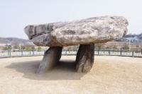
The Gochang, Hwasun and Ganghwa Dolmen Sites are locations for hundreds of dolmens used as graves and for ritual ceremonies. Most of these megalithic structures are dating from the period of the first millennium BCE. According to specialists, Korea contains more than 40% of the world's dolmen.
The site located on Gangwha Island is the easier most convenient one to visit from Seoul. From the Sinchon bus Terminal, take a bus to get to Gangwha Island bus terminal in one and a half hour and from there, take another bus to move on the island. However, the dolmen are scattered throughout the island and it is difficult to see most of them and to have a general view.
A notable dolmen on Ganghwa Island's site is a kind of table-type dolmen where it was believed ancestral rites were performed. This dolmen is thought to be the biggest in Korea.
Keep reading 0 commentsThibault Magnien
Seokguram Grotto and Bulguksa Temple
Seokguram Grotto and Bulguksa Temple (Inscribed)
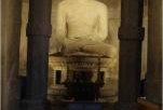
Seokguram Grotto and Bulguksa Temple form one of the most famous site in South Korea.
Bulguksa is a Buddhist temple completed in 774 by kings of Silla Kingdom (located in Gyeongju). The complex has been destroyed, and rebuilt in 1604. It has been renovated several times since there. It is home to seven National treasures of South Korea, whose the two famous stone pagodas (Dabotap and Seokgatap).
The Seokguram Grotto, is located four kilometers to the east, on the hill. You can go there from the temple either by walk through a beautiful forest way, hiking the hill, or by bus. The hiking will take you almost one hour but the frame worth it. The Grotto is almost located at the top of the hill, 750 meters above sea level.
As in the entrance of Bulguska temple, The Four Heavenly Kings guard the corridor.
Its construction began in 742 and was completed in 774. The Buddha statue it welcomes exemplifies one of the best Buddhist sculptures in the world. The Japan sea is visible from this place when clouds are not too present.
Keep reading 0 comments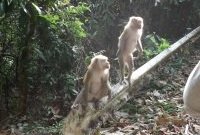
I only managed to visit two of the locations included in this site, Pang Sida NP and Khao Yai NP.
Pang Sida I accessed from Sa Kaeo, a station on the Eastern Line while travelling from Aranyaprathet to Bangkok. A 30 minute ride by tuktuk took me to the park where I visited the falls and the park headquarters. The road through the park was closed due to the clouds of butterflies swarming over the road and creating a hazard for motorists. But stopping to see this sight was amazing, especially the wide variety of different coloured creatures.
I spent three days at a small resort near Pak Chong and made several visits to various parts of the Khao Yai park. Apart from travelling the roads and visiting several waterfalls I also made two escorted forays into the jungle on foot. Here we found a wide vaiety of fauna and flora, especially numerous species of multicoloured birds. But I also encountered several types of snake, troops of macaques, clans of gibbons swinging high in the tree canopy, several species of deer. Also saw fresh elephant droppings, but failed to glimpse the animals themselves. One of the wierdest phenomena was at sundown, watching millions of bats emerge from underground caves and create huge clouds of the creatures as they set off for their nightly feeding frenzy.
Keep reading 0 comments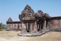
In February 2012 only a trickle of visitors were making their way to this remote site. Access from Thailand was still not available, and the site could only be approached from Kor Muy in Cambodia. Here I obtained the necessary permit to visit the site (free). Armed with this document I boarded a 4WD pick-up for the hair-raising climb up the new and almost completed road to the temple.
At the top of the road I was met by Dina, an attractive tour guide who led me through the temple to the viewpoint beyond. From here the view over Cambodia was outstanding.
Despite a small amount of damage caused by shelling by Thai forces last year, the displays of intricate stone carvings remain.
In February the site was still heavily populated by Cambodian police and soldiers, however there were no weapons to be seen.
Keep reading 0 comments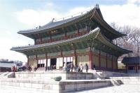
The Changdeokgung Palace is the finest example of Korean art and architecture. The building of this palace started in 1405 and was completed in 1412. It was used by many kings of the Joseon dynasty that added some elements to the original complex. The palace was completely destroyed by the Japanese and was rebuilt in 1609. Hit once again by Chinese, French and American, the complex has kept its original shape and plans. Today, 13 royal buildings are still in place in the complex as well as many others for servants the gardens.
The place is very amazing and is a great testimony of the Korean know-how in term of buildings, paintings and architecture, all that in balance with nature.
Keep reading 0 comments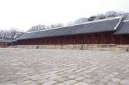
Jongmyo Shrine is a Confucian sanctuary dedicated to the Joseon dynasty dead members. It was built in 1394 by king Taejo and is then thought to be the oldest Confucian sanctuary. It was destroyed by the Japanese and rebuilt in 1601. This one is still in place. It used to welcome some of the Tripitaka Koreana, wooden tablets that are now within the Haiensa temple, as well registered as WHS.
The main distinctive element is the great square in front of the building, 150 meters long and 100 meters width. The complex is still used today for ritual ceremonies.
This site is really intersting for its architecture and its symbolism. Located in the center of Seoul, you can easily get there by subway, the syop is Jongno 3 ga on the line 1.
Keep reading 0 comments