Papua New Guinea
Upper Sepik River Basin
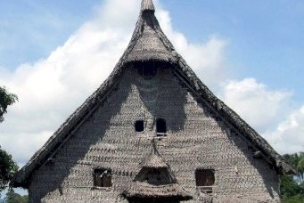
The Upper Sepik River Basin holds an undisturbed region of freshwater and rainforest, inhabited by numerous culturally diverse groups. Its fauna is especially notable for its endemic birds and fish. Culturally, the architecture of the gabled spirit houses stand out.
Site Info
Official Information
- Full Name
- Upper Sepik River Basin (ID: 5065)
- Country
- Papua New Guinea
- Status
-
On tentative list 2006
Site history
History of Upper Sepik River Basin
- 2006: Added to Tentative List
- Added to tentative list
- Type
- Mixed
- Criteria
Links
- UNESCO
- whc.unesco.org
- Related
-
- sprep.org — A detailed description of the proposal (including maps of the core zone) can be found from page 173 onward in this official report on PNG sites from 2015
All Links
UNESCO.org
- whc.unesco.org — whc.unesco.org
Related Resources
- sprep.org — A detailed description of the proposal (including maps of the core zone) can be found from page 173 onward in this official report on PNG sites from 2015
Community Information
- Community Category
- Natural landscape: Diverse ecosystems
- Cultural Landscape: Continuing
Travel Information
Recent Connections
News
No news.
Community Reviews
Show full reviews
As is often the case, the extent and possible boundaries of this T List site are not at all clear. Although the title refers to the “Upper Sepik”, the UNESCO description simply states that it covers “the middle and upper reaches of the Sepik River basin including slopes of the Central Range”. We are also told that the area is “the size of France”, whilst topographic names are limited to “the Hunstein Range Wildlife Management Area” (WMA) and the “Telefomin region”. We visited this general area in Sept 2007 - but I had always steered clear of doing a review for fear of discovering that we hadn't visited the actual TWHS! However, recent “research” I have carried out (more later) means that I now feel confident of making a valid review of it, as well as adding to the “knowledge base” about Papua New Guinea's (PNG) TWHS on this Web site.
At the time of writing, information here about PNG as a whole is very “thin” - few visits, fewer reviews, no Forum topic and no links to other informative Web sites or “News”. Yet Port Moresby (PM) is only a 1.5 hour (525 mile) flight from Cairns!! Of course you first have to get to N Queensland and then go on somewhere from "unlovely PM". Ex Europe, flights with Singapore Airlines, code sharing with Air Niugini through to PM are the most direct route – but still VERY …
Keep reading 0 comments
